
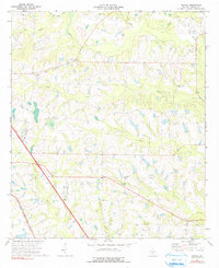
1973 Map of Bethel
USGS Topo · Published 1976About this map
Bethel serves as a quiet center point for this agricultural region of Turner County in the early 1970s. The landscape is defined by a dense network of watercourses including Deep Creek, Wolf Creek, and Sand Creek, which carve through the terrain. Evidence of the mid-century rural infrastructure is visible through landmarks such as the Lookout Tower and Olsens Air Park. Transportation and local commerce are anchored by the Georgia Southern and Florida railroad corridor running diagonally through the western section.
Find a feature on this map
26 named features on this map. Tap any name to fly to it.
Don’t see what you’re looking for? This feature index may not catch every label — zoom into the map to look around manually.
Map Details
Editions of this 1973 Bethel Map
2 editions found
Other maps of this area

1953 · Waycross
USGS Topo · 1:250,000

1958 · Waycross
USGS Topo · 1:250,000

1973 · Sumner
USGS Topo · 1:24,000

1973 · Waterloo
USGS Topo · 1:24,000

1973 · Irwinville
USGS Topo · 1:24,000

1973 · Ashburn
USGS Topo · 1:24,000

1973 · Chula
USGS Topo · 1:24,000

1974 · Rebecca
USGS Topo · 1:24,000

1974 · Amboy
USGS Topo · 1:24,000
1977 · Arabi
USGS Topo · 1:24,000