
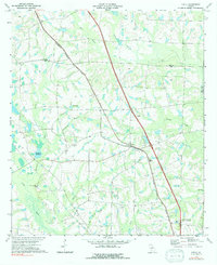
1973 Map of Chula
USGS Topo · Published 1976About this map
Chula serves as the central hub of this agricultural landscape in Tift County, where the Georgia Southern and Florida railroad and the highway network intersect. The map illustrates a community deeply rooted in rural development during the early 1970s, evidenced by the presence of the University of Georgia Research Laboratories in the southeast. Water management and local industry are visible through features like Whiddons Millpond and the various branches feeding into the Little River. Small settlements such as Inaha and Sunsweet are connected by rural roads and rail lines, while local life is centered around institutions like Mt Zion Ch, Friendship Ch, and Tift Sch. The geography is defined by a dense network of creek systems, including Hat Creek, Heard Creek, and Old Field Creek, which carve through the south-central Georgia terrain.
Find a feature on this map
32 named features on this map. Tap any name to fly to it.
Don’t see what you’re looking for? This feature index may not catch every label — zoom into the map to look around manually.
Map Details
Editions of this 1973 Chula Map
2 editions found
Other maps of this area

1953 · Waycross
USGS Topo · 1:250,000

1958 · Waycross
USGS Topo · 1:250,000

1973 · Sumner
USGS Topo · 1:24,000

1973 · Ty Ty
USGS Topo · 1:24,000

1973 · Waterloo
USGS Topo · 1:24,000

1973 · Irwinville
USGS Topo · 1:24,000

1973 · Ashburn
USGS Topo · 1:24,000

1973 · Tifton East
USGS Topo · 1:24,000

1973 · Tifton West
USGS Topo · 1:24,000

1973 · Bethel
USGS Topo · 1:24,000