
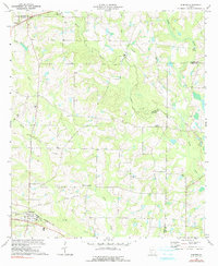
1973 Map of Sumner
USGS Topo · Published 1975About this map
The Seaboard Coast Line railroad anchors the southern edge of this landscape, passing through the town of Sumner, which serves as a local hub for this part of Worth County. In the early 1970s, the surrounding countryside was characterized by a dense network of rural spiritual centers and small community landmarks, reflecting a well-established social fabric. Named congregations such as New Mt Pleasant Ch, Millers Chapel, and Clements Chapel are scattered throughout the quadrangle, often situated near watercourses like Ty Ty Creek or Daniels Creek. To the northwest, the settlement of Terrell sits near the Turner County line, while the presence of the Old Sumner Cem and the Parker Sch offer important touchstones for those researching family history in the region. The terrain is defined by the slow drainage of the Little River and its numerous tributaries, including the distinctively named Lime Sink Creek.
Find a feature on this map
25 named features on this map. Tap any name to fly to it.
Don’t see what you’re looking for? This feature index may not catch every label — zoom into the map to look around manually.
Map Details
Editions of this 1973 Sumner Map
2 editions found
Other maps of this area

1953 · Waycross
USGS Topo · 1:250,000

1956 · Sylvester
USGS Topo · 1:62,500

1956 · Doerun
USGS Topo · 1:62,500

1958 · Waycross
USGS Topo · 1:250,000

1972 · Cuffietown
USGS Topo · 1:24,000

1973 · Ty Ty
USGS Topo · 1:24,000

1973 · Sylvester
USGS Topo · 1:24,000

1973 · Ashburn
USGS Topo · 1:24,000

1973 · Chula
USGS Topo · 1:24,000

1973 · Tifton West
USGS Topo · 1:24,000