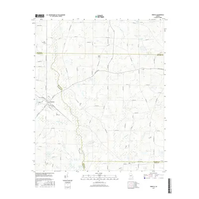
2017 Map of Rebecca
USGS Topo · Published 2017About this map
The town of Rebecca serves as a focal point in this South Georgia landscape, where agricultural land meets the winding course of the Alapaha River. The area is characterized by its numerous small family and community burial sites, which provide significant genealogical value for the region. These include Taylor Cem, Paulk Cem, Piney Grove Cem, and New Providence Cem, among others, scattered across the county lines of Turner, Wilcox, Ben Hill, and Irwin. This confluence of four counties creates a complex jurisdictional layout, with the small community of Arp situated near the southern border. The terrain is defined by a network of drainage creeks such as Double Run Cr, Young Cr, and Willis Cr, which feed into various water bodies like Reeves Lake and Brown Lake. The road network is primarily composed of county routes like Double Run Rd and Salem Church Rd, connecting the scattered rural residences and church communities that define this corner of the Georgia coastal plain.
Find a feature on this map
103 named features on this map. Tap any name to fly to it.
Don’t see what you’re looking for? This feature index may not catch every label — zoom into the map to look around manually.
Map Details
Editions of this 2017 Rebecca Map
This is the sole edition of this map. No revisions or reprints were ever made.
Other maps of this area

1953 · Waycross
USGS Topo · 1:250,000

1958 · Waycross
USGS Topo · 1:250,000

1973 · Irwinville
USGS Topo · 1:24,000

1973 · Bethel
USGS Topo · 1:24,000

1973 · Fitzgerald West
USGS Topo · 1:24,000

1974 · Rebecca
USGS Topo · 1:24,000
1974 · Abbeville South
USGS Topo · 1:24,000
1974 · Pitts
USGS Topo · 1:24,000

1974 · Amboy
USGS Topo · 1:24,000
1977 · Rochelle
USGS Topo · 1:24,000