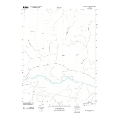
2010 Map of Recapture Pocket
USGS Topo · Published 2010About this map
Seventeen Room Ruin stands as a significant archaeological landmark overlooking the San Juan River on the southern edge of this San Juan County landscape. The terrain is characterized by high plateaus and deep drainage systems, where Recapture Creek flows south toward its confluence with the river. To the north, the distinctive Chimney Rocks and Chimney Rock Draw punctuate the arid landscape. The map details a network of early 21st-century access points, including Trading Post Rd and Mission RD, which navigate between prominent landforms like Bluff Bench and McCracken Mesa. This survey documents a region of high mesas, such as Casa Del Eco Mesa, where the river carving through the canyon floor has historically dictated movement and settlement patterns.
Find a feature on this map
25 named features on this map. Tap any name to fly to it.
Don’t see what you’re looking for? This feature index may not catch every label — zoom into the map to look around manually.
Map Details
Editions of this 2010 Recapture Pocket Map
This is the sole edition of this map. No revisions or reprints were ever made.
Other maps of this area

1886 · Abajo
USGS Topo · 1:250,000

1892 · Abajo
USGS Topo · 1:250,000

1893 · Abajo
USGS Topo · 1:250,000

1956 · Cortez
USGS Topo · 1:250,000

1958 · Cortez
USGS Topo · 1:250,000

1959 · Cortez
USGS Topo · 1:250,000

1962 · Cortez
USGS Topo · 1:250,000

1962 · Montezuma Creek
USGS Topo · 1:62,500

1962 · Bluff
USGS Topo · 1:62,500
1962 · Boundary Butte
USGS Topo · 1:62,500