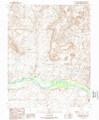
1989 Map of Recapture Pocket
USGS Topo · Published 1989About this map
The San Juan River flows through this corner of San Juan County, cutting a prominent path south of the Navajo Indian Reservation boundary. In the late 1980s, the landscape was defined by its geological features and active resource extraction, with numerous Oil Wells and Drill Holes dotting the mesas. Distinctive landmarks such as Chimney Rocks and the winding Recapture Creek provide navigational anchors in a terrain of high plateaus and deep canyons.
Find a feature on this map
24 named features on this map. Tap any name to fly to it.
Don’t see what you’re looking for? This feature index may not catch every label — zoom into the map to look around manually.
Map Details
Editions of this 1989 Recapture Pocket Map
This is the sole edition of this map. No revisions or reprints were ever made.
Other maps of this area

1886 · Abajo
USGS Topo · 1:250,000

1892 · Abajo
USGS Topo · 1:250,000

1893 · Abajo
USGS Topo · 1:250,000

1956 · Cortez
USGS Topo · 1:250,000

1958 · Cortez
USGS Topo · 1:250,000

1959 · Cortez
USGS Topo · 1:250,000

1962 · Cortez
USGS Topo · 1:250,000

1962 · Montezuma Creek
USGS Topo · 1:62,500

1962 · Bluff
USGS Topo · 1:62,500
1962 · Boundary Butte
USGS Topo · 1:62,500