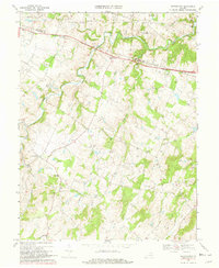
1970 Map of Rectortown
USGS Topo · Published 1981About this map
Rectortown serves as a central hub in this Virginia landscape, situated along the Southern railroad line as it crosses the border between Loudoun Co and Fauquier Co. The terrain is defined by a dense network of winding watercourses, including the prominent Goose Creek and Cromwells Run, which have shaped the local settlement patterns. Notable institutional landmarks such as Notre Dame Academy, Northwestern Sch, and the Middleburg Training Track reflect the region's long-standing connection to education and equestrian heritage.
Find a feature on this map
21 named features on this map. Tap any name to fly to it.
Don’t see what you’re looking for? This feature index may not catch every label — zoom into the map to look around manually.
Map Details
Editions of this 1970 Rectortown Map
3 editions found
Other maps of this area

1884 · Harpers Ferry
USGS Topo · 1:125,000

1891 · Harpers Ferry
USGS Topo · 1:125,000

1893 · Harpers Ferry
USGS Topo · 1:125,000

1894 · Warrenton
USGS Topo · 1:125,000

1916 · Berryville
USGS Topo · 1:62,500

1933 · Middleburg
USGS Topo · 1:62,500

1939 · Berryville
USGS Topo · 1:48,000

1943 · Bluemont
USGS Topo · 1:24,000

1943 · Thorofare Gap
USGS Topo · 1:24,000

1943 · Orlean
USGS Topo · 1:24,000