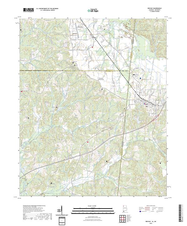
2024 Map of Red Bay
USGS Topo · Published 2024About this map
Red Bay and Belmont anchor this detailed study of the Alabama-Mississippi borderlands, where the Tennessee Valley Divide and the Freedom Hills shape the regional hydrology. The map documents a dense network of local cemeteries, including the Burges Cem African American, New Bethel Cem, and Hillcrest Memorial Gardens, providing essential data for genealogical research. Waterways like Bear Creek and the forks of Chubby Creek drain the dissected terrain, while the Tishomingo County Airport and a centralized hospital highlight the modern infrastructure of the 2020s. Small rural communities like Golden are connected by a web of county roads such as Snake Smith Rd and Chicken House RD, reflecting a landscape defined by its timbered ridges and the small-scale reservoirs of Bates Lake and Berry Lake.
Find a feature on this map
152 named features on this map. Tap any name to fly to it.
Don’t see what you’re looking for? This feature index may not catch every label — zoom into the map to look around manually.
Map Details
Editions of this 2024 Red Bay Map
This is the sole edition of this map. No revisions or reprints were ever made.
Other maps of this area

1935 · Pleasant Site
USGS Topo · 1:24,000

1936 · Belmont
USGS Topo · 1:24,000

1936 · Red Bay
USGS Topo · 1:24,000

1936 · Vina
USGS Topo · 1:24,000

1936 · Halltown
USGS Topo · 1:24,000

1950 · Belmont
USGS Topo · 1:24,000

1950 · Vina
USGS Topo · 1:24,000
1950 · Halltown
USGS Topo · 1:24,000
1950 · Pleasant Site
USGS Topo · 1:24,000
1951 · Pleasant Site
USGS Topo · 1:24,000