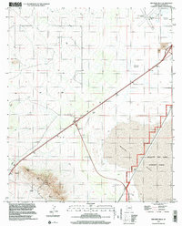
1996 Map of Red Bird Hills
USGS Topo · Published 2002About this map
Willcox Dry Lake Playa dominates the southeastern portion of this landscape, its expansive surface characteristic of the arid basin terrain of Cochise County. This 1996 survey illustrates the intersection of industrial activity and military history, with a designated Bombing Range and its associated Military Reservation Boundary cutting through the eastern flats. To the west, the Red Bird Hills rise sharply from the basin floor, marked by numerous small-scale mining operations including several prospects and mines. The transportation and utility infrastructure is clearly defined, showing the proximity of the Cochise County Airport and the sparse, straight-line roads that navigate around the Alkali Flats. This sheet provides a detailed look at the resource extraction and defense-related land use that shaped this part of the Arizona desert during the late twentieth century.
Find a feature on this map
11 named features on this map. Tap any name to fly to it.
Don’t see what you’re looking for? This feature index may not catch every label — zoom into the map to look around manually.
Map Details
Editions of this 1996 Red Bird Hills Map
This is the sole edition of this map. No revisions or reprints were ever made.
Other maps of this area

1922 · Willcox
USGS Topo · 1:125,000

1943 · Willcox
USGS Topo · 1:62,500

1943 · Cochise
USGS Topo · 1:62,500

1943 · Dragoon
USGS Topo · 1:62,500

1943 · Winchester Mts.
USGS Topo · 1:62,500

1945 · Winchester Mts.
USGS Topo · 1:62,500

1954 · Silver City
USGS Topo · 1:250,000

1956 · Tucson
USGS Topo · 1:250,000

1957 · Winchester Mts.
USGS Topo · 1:62,500

1958 · Silver City
USGS Topo · 1:250,000