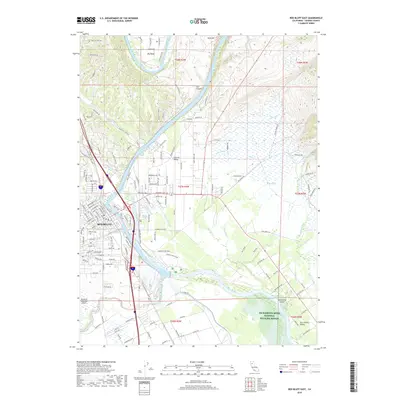
2018 Map of Red Bluff East
USGS Topo · Published 2018About this map
Red Bluff serves as the focal point for this survey of the northern Sacramento Valley, where the winding Sacramento River carves through landmarks like Iron Canyon and Big Bend. The map documents a complex hydraulic landscape defined by the Corning Canal and Tehama-Colusa Canal, infrastructure essential to the region's agricultural character. Residential expansion is visible in areas like Central Valley, while the southern reaches are preserved within the Sacramento River National Wildlife Refuge. Local history is anchored by the Oak Hill Cem and the Red Bluff Municipal Airport, reflecting the city's development as a regional hub. Numerous waterways, including Paynes Cr Slough and Samson Slough, crisscross the lowlands, illustrating the intricate drainage patterns that have shaped land use and settlement since the city's founding.
Find a feature on this map
167 named features on this map. Tap any name to fly to it.
Don’t see what you’re looking for? This feature index may not catch every label — zoom into the map to look around manually.
Map Details
Editions of this 2018 Red Bluff East Map
This is the sole edition of this map. No revisions or reprints were ever made.
Other maps of this area

1890 · Red Bluff
USGS Topo · 1:250,000

1894 · Red Bluff
USGS Topo · 1:250,000

1905 · Tehama
USGS Topo · 1:62,500

1944 · Tuscan Buttes
USGS Topo · 1:62,500

1947 · Tuscan Buttes
USGS Topo · 1:62,500

1947 · Anderson
USGS Topo · 1:62,500

1948 · Anderson
USGS Topo · 1:62,500

1950 · Gerber
USGS Topo · 1:24,000

1951 · Gerber
USGS Topo · 1:24,000

1951 · Red Bluff East
USGS Topo · 1:24,000