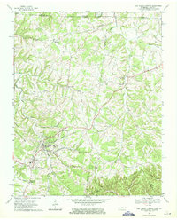
1968 Map of Red Boiling Springs
USGS Topo · Published 1971About this map
Red Boiling Springs serves as the focal point of this rural borderland, where the intricate branching of Salt Lick Creek and Line Creek defines the landscape. The region's settlement pattern is deeply tied to its geography, with communities like Hermitage Springs, Walnut Shade, and Spivey clustered near reliable water sources and creek junctions. The social fabric of the 1960s is evidenced by numerous landmarks, including Smith Chapel and Bethany Ch, alongside family-named plots like Biles Cem and Turner Cem.
Find a feature on this map
54 named features on this map. Tap any name to fly to it.
Don’t see what you’re looking for? This feature index may not catch every label — zoom into the map to look around manually.
Map Details
Editions of this 1968 Red Boiling Springs Map
This is the sole edition of this map. No revisions or reprints were ever made.
Other maps of this area

1925 · Gainesboro
USGS Topo · 1:62,500

1929 · Gainesboro
USGS Topo · 1:62,500

1929 · Tompkinsville
USGS Topo · 1:62,500

1931 · Red Boiling Springs
USGS Topo · 1:62,500

1932 · Carthage
USGS Topo · 1:62,500

1954 · Fountain Run
USGS Topo · 1:24,000

1954 · Gamaliel
USGS Topo · 1:24,000

1954 · Tompkinsville
USGS Topo · 1:24,000

1956 · Corbin
USGS Topo · 1:250,000

1958 · Corbin
USGS Topo · 1:250,000