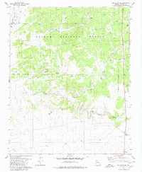
1980 Map of Red Butte SW
USGS Topo · Published 1980About this map
Anita Station serves as a primary marker of the high plateau landscape south of the Grand Canyon, situated along the Atchison Topeka and Santa Fe railroad line. This 1980 edition illustrates the utilitarian nature of the high desert, where water management is critical to ranching and local operations, as evidenced by numerous livestock tanks like Anita Tank, Sixty Two Tank, and Red Horse Tank.
Find a feature on this map
19 named features on this map. Tap any name to fly to it.
Don’t see what you’re looking for? This feature index may not catch every label — zoom into the map to look around manually.
Map Details
Editions of this 1980 Red Butte SW Map
2 editions found
Other maps of this area

1886 · Chino
USGS Topo · 1:250,000

1891 · Chino
USGS Topo · 1:250,000

1948 · Williams
USGS Topo · 1:250,000

1954 · Williams
USGS Topo · 1:250,000
1956 · Red Butte SE
USGS Topo · 1:24,000

1956 · Williams
USGS Topo · 1:250,000

1960 · Williams
USGS Topo · 1:250,000

1961 · Williams
USGS Topo · 1:250,000

1962 · Valle
USGS Topo · 1:62,500
1979 · Red Butte
USGS Topo · 1:24,000