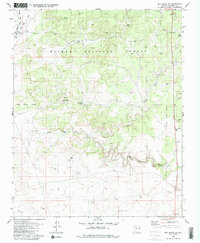
1980 Map of Red Butte SW
USGS Topo · Published 1980About this map
Kaibab National Forest dominates this northern Arizona landscape, where the high-plateau drainage systems of Red Horse Wash and Little Red Horse Wash carve through the terrain. The infrastructure of the Atchison Topeka and Santa Fe railroad skirts the northwestern corner, serving the remote outpost of Anita Station. This area is defined by its water management and mineral extraction history, characterized by numerous named catchment basins such as Rain Tank, Java Tank, and Sixty Two Tank. These tanks were essential for supporting livestock and steam locomotives in the arid environment. Resource extraction is represented by the Copper Queen Mine and several Prospects, highlighting the era's focus on identifying valuable deposits within the Coconino County uplands.
Find a feature on this map
18 named features on this map. Tap any name to fly to it.
Don’t see what you’re looking for? This feature index may not catch every label — zoom into the map to look around manually.
Map Details
Editions of this 1980 Red Butte SW Map
2 editions found
Other maps of this area

1886 · Chino
USGS Topo · 1:250,000

1891 · Chino
USGS Topo · 1:250,000

1948 · Williams
USGS Topo · 1:250,000

1954 · Williams
USGS Topo · 1:250,000
1956 · Red Butte SE
USGS Topo · 1:24,000

1956 · Williams
USGS Topo · 1:250,000

1960 · Williams
USGS Topo · 1:250,000

1961 · Williams
USGS Topo · 1:250,000

1962 · Valle
USGS Topo · 1:62,500
1979 · Red Butte
USGS Topo · 1:24,000