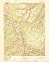
1950 Map of Red Canyon
USGS Topo · Published 1950About this map
The Dolores River and San Miguel River carve deep through the mesas of southwestern Colorado in this 1950 survey, produced in conjunction with the United States Atomic Energy Commission. This partnership reflects the era's intensive geological focus on uranium-bearing regions. The landscape is dominated by mining activity, particularly concentrated along the canyon walls and river bends. Active and inactive sites like the North Star Mine, Black Rock Mine, and Shamrock Mines suggest a specialized extraction economy, while the Cliff Dweller Mine and Ophir Mine overlook the confluence of the two rivers. Transportation is largely limited to rudimentary paths such as the Radium Trail and Stock Trail, which navigate the steep elevations between Blue Mesa and Atkinson Mesa. The isolated Club Ranch stands as the primary named settlement, located near the eastern map boundary.
Find a feature on this map
36 named features on this map. Tap any name to fly to it.
Don’t see what you’re looking for? This feature index may not catch every label — zoom into the map to look around manually.
Map Details
Editions of this 1950 Red Canyon Map
2 editions found
Other maps of this area

1916 · Paradox Valley
USGS Topo · 1:125,000

1922 · Paradox Valley
USGS Topo · 1:125,000

1948 · Roc Creek
USGS Topo · 1:24,000

1948 · Uravan
USGS Topo · 1:24,000

1948 · Paradox
USGS Topo · 1:24,000

1949 · Davis Mesa
USGS Topo · 1:24,000

1949 · Uravan
USGS Topo · 1:24,000

1949 · Paradox
USGS Topo · 1:24,000

1949 · Roc Creek
USGS Topo · 1:24,000

1949 · Juanita Arch
USGS Topo · 1:24,000