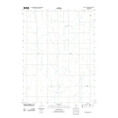
2011 Map of Red Cloud NW
USGS Topo · Published 2011About this map
West Fork Farmers Creek and its neighboring tributaries define the drainage patterns of this rural Webster County landscape. This agricultural region is characterized by a high density of historical burial sites, including the Catherton Cemetery in the north and the Pleasant Prairie Cemetery to the south. These cemeteries, alongside Zion Cemetery and New Virginia Cemetery, serve as primary genealogical anchors for the area's farming families. Water management is a visible priority on the land, most notably at the Bartell Reservoir and its associated Bartell Dam situated along the East Fork Farmers Creek. The grid of county roads provides access to these remote landmarks, while smaller drainages like Sassacus Creek and Spring Creek further segment the terrain.
Find a feature on this map
12 named features on this map. Tap any name to fly to it.
Don’t see what you’re looking for? This feature index may not catch every label — zoom into the map to look around manually.
Map Details
Editions of this 2011 Red Cloud NW Map
This is the sole edition of this map. No revisions or reprints were ever made.
Other maps of this area

1897 · Red Cloud
USGS Topo · 1:125,000

1940 · Red Cloud
USGS Topo · 1:62,500

1942 · Red Cloud
USGS Topo · 1:62,500

1955 · Grand Island
USGS Topo · 1:250,000

1957 · Grand Island
USGS Topo · 1:250,000

1958 · Grand Island
USGS Topo · 1:250,000

1969 · Upland SE
USGS Topo · 1:24,000
1969 · Campbell
USGS Topo · 1:24,000
1969 · Bladen
USGS Topo · 1:24,000
1974 · Riverton
USGS Topo · 1:24,000