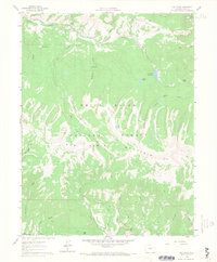
1961 Map of Red Creek
USGS Topo · Published 1968About this map
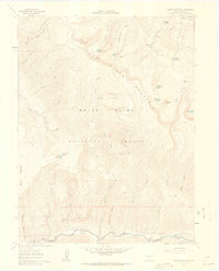
Red Table Mountain dominates the center of this high-elevation landscape within the White River National Forest, forming a massive east-west divide between the drainages of the Fryingpan River and Gypsum Creek. The map documents a wilderness transitioning into a managed recreational and water-resource area in the early 1960s. High-altitude landmarks like Lost Lake and the Ragged Lakes are connected by an extensive network of Pack Trails, while the L. E. D. E. Reservoir and Antoine Spring suggest the importance of water management in this arid alpine environment. In the southern reaches, evocative names such as Saloon Gulch and Frenchman Creek hint at the area's prospecting or early settlement history. The presence of the Red Creek Campground and various Jeep Trails underscores the shift toward seasonal recreation and forestry access during this era.
Find a feature on this map
39 named features on this map. Tap any name to fly to it.
Don’t see what you’re looking for? This feature index may not catch every label — zoom into the map to look around manually.
Map Details
Editions of this 1961 Red Creek Map
5 editions found

Other maps of this area

1909 · Mount Jackson
USGS Topo · 1:125,000

1911 · Mount Jackson
USGS Topo · 1:125,000

1957 · Leadville
USGS Topo · 1:250,000

1959 · Leadville
USGS Topo · 1:250,000

1960 · Leadville
USGS Topo · 1:250,000
1961 · Woody Creek
USGS Topo · 1:24,000

1961 · Ruedi
USGS Topo · 1:24,000
1961 · Toner Reservoir
USGS Topo · 1:24,000

1961 · Red Creek
USGS Topo · 1:24,000

1962 · Leadville
USGS Topo · 1:250,000