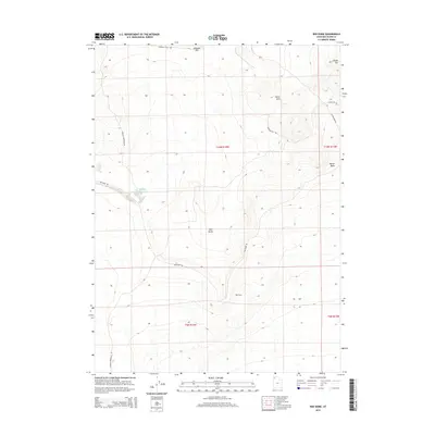
2014 Map of Red Dome
USGS Topo · Published 2014About this map
Red Dome stands as a prominent landmark within this arid Box Elder County landscape, anchoring a terrain defined by desert basins and isolated elevations. The geography is marked by the presence of Matlin Basin to the east and the Horse Hills to the north, reflecting a region where water management is critical, as seen at Pugsley Reservoir. Transportation routes like Terrace Mountain Rd and Red Dome Rd navigate the contours of the high desert, providing access through the basin-and-range topography. A significant historical connection is preserved along the northern edge of the map where Emigrant Trail Rd follows a legacy corridor of westward expansion. Other distinct high points, such as Airplane Hill and Coyote Hill, serve as natural waypoints in this open country, illustrating the land-use patterns of Northern Utah's high desert during the early twenty-first century.
Find a feature on this map
17 named features on this map. Tap any name to fly to it.
Don’t see what you’re looking for? This feature index may not catch every label — zoom into the map to look around manually.
Map Details
Editions of this 2014 Red Dome Map
This is the sole edition of this map. No revisions or reprints were ever made.
Other maps of this area

1954 · Brigham City
USGS Topo · 1:250,000

1958 · Brigham City
USGS Topo · 1:250,000

1962 · Brigham City
USGS Topo · 1:250,000

1971 · Prohibition Spring
USGS Topo · 1:24,000

1971 · Red Dome
USGS Topo · 1:24,000

1971 · Matlin
USGS Topo · 1:24,000
1971 · Runswick Wash
USGS Topo · 1:24,000

1971 · Warm Spring Hills
USGS Topo · 1:24,000
1971 · Russian Knoll
USGS Topo · 1:24,000

1983 · Terrace Mountain West
USGS Topo · 1:24,000