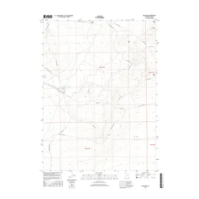
2017 Map of Red Dome
USGS Topo · Published 2017About this map
Old Railroad Grade Rd cuts a clear path across this high desert landscape, tracing a historic transportation corridor through the Great Basin. The terrain is defined by prominent volcanic features and isolated peaks such as Red Dome and Airplane Hill, which provided navigational landmarks for travelers along the nearby Emigrant Trail Rd. This 2017 survey by the U.S. Geological Survey documents the remote northwestern Utah landscape, where sparse water sources like Pugsley Reservoir are critical points in the arid environment. The map shows the transition from the Matlin Basin up into the higher elevations of the Horse Hills and Coyote Hill. Researchers can trace the legacy of pioneer and rail history through the naming conventions of the roads and trails that continue to navigate these ancient lake beds and mountain flanks.
Find a feature on this map
22 named features on this map. Tap any name to fly to it.
Don’t see what you’re looking for? This feature index may not catch every label — zoom into the map to look around manually.
Map Details
Editions of this 2017 Red Dome Map
This is the sole edition of this map. No revisions or reprints were ever made.
Other maps of this area

1954 · Brigham City
USGS Topo · 1:250,000

1958 · Brigham City
USGS Topo · 1:250,000

1962 · Brigham City
USGS Topo · 1:250,000

1971 · Prohibition Spring
USGS Topo · 1:24,000

1971 · Red Dome
USGS Topo · 1:24,000

1971 · Matlin
USGS Topo · 1:24,000
1971 · Runswick Wash
USGS Topo · 1:24,000

1971 · Warm Spring Hills
USGS Topo · 1:24,000
1971 · Russian Knoll
USGS Topo · 1:24,000

1983 · Terrace Mountain West
USGS Topo · 1:24,000