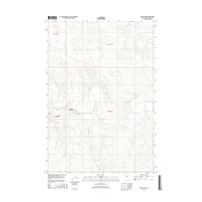
2015 Map of Red Elm NE
USGS Topo · Published 2015About this map
The Iron Lightning settlement occupies a central position in this prairie landscape, situated near the sweeping curves of the Moreau River. This 2015 survey reflects the geography of Ziebach County where the river system creates a significant hydrological network including Thunder Butte Cr and Knife Cr. The community's local history is anchored by the Iron Lightning Cem located just north of Iron Lightning Rd. The topographic data highlights how the terrain undulates between these watercourses, particularly around the confluence points of Cottonwood Cr and the main river channel. This area illustrates the late twentieth and early twenty-first century settlement patterns of the Cheyenne River Indian Reservation, where primary access routes and small communities remain closely tied to the natural drainage systems of the plains.
Find a feature on this map
11 named features on this map. Tap any name to fly to it.
Don’t see what you’re looking for? This feature index may not catch every label — zoom into the map to look around manually.
Map Details
Editions of this 2015 Red Elm NE Map
This is the sole edition of this map. No revisions or reprints were ever made.
Other maps of this area

1951 · Redelm NE
USGS Topo · 1:24,000

1951 · Redelm NW
USGS Topo · 1:24,000

1951 · Thunder Butte
USGS Topo · 1:24,000

1953 · McIntosh
USGS Topo · 1:250,000

1958 · McIntosh
USGS Topo · 1:250,000

1979 · Dupree
USGS Topo · 1:25,000

1982 · Glad Valley SW
USGS Topo · 1:24,000

1982 · Irish Creek SW
USGS Topo · 1:24,000
1982 · Red Elm
USGS Topo · 1:24,000

1982 · Glad Valley SE
USGS Topo · 1:24,000