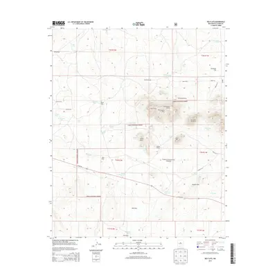
2013 Map of Red Flats
USGS Topo · Published 2013About this map
The Continental Divide traverses the center of this landscape, marking a significant hydrologic boundary within the Cibola National Forest. The map is characterized by a network of ranching infrastructure, primarily stock tanks named for local families and landmarks, such as McWhorter Tank, Glasscock Tank, and Holden Tank. These water sources are vital in the arid terrain surrounding the Sawtooth Mountains and the distinctive geological profiles of Capital Dome and Castle Dome. In the southern half, US Hwy 60 cuts through the region near Red Flats, providing the primary east-west transit route. The terrain reveals a complex system of drainage draws including Newton Draw and Pino Draw, while landmarks like the Airplane Hills and Lone Mtn serve as prominent navigational aids for travelers and land managers in this high-elevation New Mexico interior.
Find a feature on this map
54 named features on this map. Tap any name to fly to it.
Don’t see what you’re looking for? This feature index may not catch every label — zoom into the map to look around manually.
Map Details
Editions of this 2013 Red Flats Map
This is the sole edition of this map. No revisions or reprints were ever made.
Other maps of this area

1954 · Saint Johns
USGS Topo · 1:250,000

1954 · Socorro
USGS Topo · 1:250,000

1957 · Saint Johns
USGS Topo · 1:250,000

1958 · Socorro
USGS Topo · 1:250,000

1958 · Saint Johns
USGS Topo · 1:250,000

1962 · Socorro
USGS Topo · 1:250,000

1962 · Saint Johns
USGS Topo · 1:250,000

1964 · Third Canyon
USGS Topo · 1:24,000
1964 · Madre Mountain
USGS Topo · 1:24,000

1964 · Crosby Springs
USGS Topo · 1:24,000