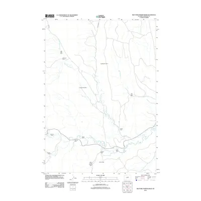
2012 Map of Red Fork Powder River
USGS Topo · Published 2012About this map
The Red Fork Powder River and Middle Fork Powder River converge in this high-plains landscape, where the importance of water management is clearly defined by a series of irrigation channels. Historic water rights are represented by the presence of the Comstock Ditch, Keith Ditch, and David Kinker Ditch, which follow the contours of the river valleys to support ranching operations. The terrain is marked by distinctive geological features such as Red Wall Number 1 and Red Wall Number 2, which flank the northern drainage of Cottonwood Cr. Numerous named draws, including Johnson Draw and Smith Draw, carve into the high ground of Harlan Ridge, revealing a rugged topography that has dictated local travel and land use for generations. This survey reflects the enduring character of Wyoming's ranching country, where names like Freeman Ditch and Brock Rd link the modern landscape to early settlement patterns and family-run agricultural tracts.
Find a feature on this map
25 named features on this map. Tap any name to fly to it.
Don’t see what you’re looking for? This feature index may not catch every label — zoom into the map to look around manually.
Map Details
Editions of this 2012 Red Fork Powder River Map
This is the sole edition of this map. No revisions or reprints were ever made.
Other maps of this area

1955 · Arminto
USGS Topo · 1:250,000

1958 · Arminto
USGS Topo · 1:250,000

1961 · Barnum
USGS Topo · 1:62,500

1961 · TTT Ranch
USGS Topo · 1:24,000

1961 · Hibbard Draw
USGS Topo · 1:24,000

1961 · Kaycee
USGS Topo · 1:24,000

1962 · Arminto
USGS Topo · 1:250,000

1963 · Mayoworth
USGS Topo · 1:62,500
1979 · Red Fork Powder River
USGS Topo · 1:24,000
1979 · Mayoworth
USGS Topo · 1:24,000