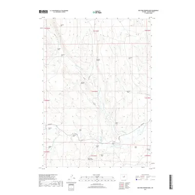
2017 Map of Red Fork Powder River
USGS Topo · Published 2017About this map
Red Fork Powder River and Middle Fork Powder River carve through this Johnson County landscape, defined by a complex network of canyons and draws. This 2017 survey details the sophisticated water management systems utilized by local ranchers, including the Keith Ditch, Comstock Ditch, and David Kinker Ditch. The terrain is marked by distinctive geological formations such as Red Wall Number 1 and Red Wall Number 2, which overlook deep-cut drainages like Starvation Draw and Rim Rock Draw. Roads such as Barnum Rd and Brock Rd provide access to the remote draws, while elevations rise significantly at Gardner Mtn in the north. The abundance of named family and descriptive landmarks, from Johnson Draw to Embry Draw, suggests a long history of land use and livestock grazing in these high plains.
Find a feature on this map
37 named features on this map. Tap any name to fly to it.
Don’t see what you’re looking for? This feature index may not catch every label — zoom into the map to look around manually.
Map Details
Editions of this 2017 Red Fork Powder River Map
This is the sole edition of this map. No revisions or reprints were ever made.
Other maps of this area

1955 · Arminto
USGS Topo · 1:250,000

1958 · Arminto
USGS Topo · 1:250,000

1961 · Barnum
USGS Topo · 1:62,500

1961 · TTT Ranch
USGS Topo · 1:24,000

1961 · Hibbard Draw
USGS Topo · 1:24,000

1961 · Kaycee
USGS Topo · 1:24,000

1962 · Arminto
USGS Topo · 1:250,000

1963 · Mayoworth
USGS Topo · 1:62,500
1979 · Red Fork Powder River
USGS Topo · 1:24,000
1979 · Mayoworth
USGS Topo · 1:24,000