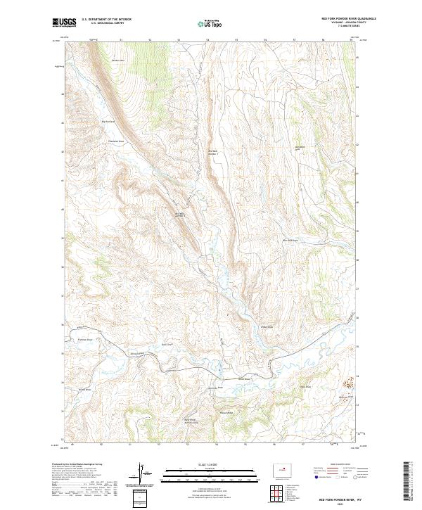
2021 Map of Red Fork Powder River
USGS Topo · Published 2021About this map
Red Fork Powder River and Middle Fork Powder River converge in this high-plains landscape of Johnson County, Wyoming. The terrain is defined by a series of deep drainages and ridges, including the prominent Harlan Ridge and the distinctively named Red Wall Number 1 and Red Wall Number 2. A network of early irrigation infrastructure, such as the Comstock Ditch, Keith Ditch, and David-Kinker Ditch, illustrates the historical effort to manage water for ranching in this arid environment. The map details various family-named and descriptive landmarks, from Gardner Mtn in the north to Starvation Draw and Peterson Draw further south. Modern access is marked by Barnum Rd, Brock Rd, and Red Canyon Rd, which navigate the draws and canyons that define the local geography.
Find a feature on this map
35 named features on this map. Tap any name to fly to it.
Don’t see what you’re looking for? This feature index may not catch every label — zoom into the map to look around manually.
Map Details
Editions of this 2021 Red Fork Powder River Map
This is the sole edition of this map. No revisions or reprints were ever made.
Other maps of this area

1955 · Arminto
USGS Topo · 1:250,000

1958 · Arminto
USGS Topo · 1:250,000

1961 · Barnum
USGS Topo · 1:62,500

1961 · TTT Ranch
USGS Topo · 1:24,000

1961 · Hibbard Draw
USGS Topo · 1:24,000

1961 · Kaycee
USGS Topo · 1:24,000

1962 · Arminto
USGS Topo · 1:250,000

1963 · Mayoworth
USGS Topo · 1:62,500
1979 · Red Fork Powder River
USGS Topo · 1:24,000
1979 · Mayoworth
USGS Topo · 1:24,000