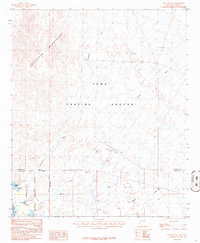
1986 Map of Red Hill SW
USGS Topo · Published 1986About this map
The Chocolate Mountains dominate the western landscape of this mid-1980s topographic record, where the arid terrain meets the vital waters of the Colorado River. The map documents a significant intersection of military and conservation land use, with the vast Yuma Proving Ground covering much of the central and eastern portions. Along the river corridor, the Imperial National Wildlife Refuge protects the riparian ecosystem, including Mc Allister Lake and shoreline features like Mesquite Point and Palo Verde Point.
Find a feature on this map
17 named features on this map. Tap any name to fly to it.
Don’t see what you’re looking for? This feature index may not catch every label — zoom into the map to look around manually.
Map Details
Editions of this 1986 Red Hill SW Map
This is the sole edition of this map. No revisions or reprints were ever made.
Other maps of this area

1903 · Yuma
USGS Topo · 1:125,000

1905 · Yuma
USGS Topo · 1:125,000

1929 · Laguna
USGS Topo · 1:62,500

1939 · Red Hill
USGS Topo · 1:62,500

1942 · Yuma
USGS Topo · 1:250,000

1942 · Blythe
USGS Topo · 1:250,000

1943 · Laguna
USGS Topo · 1:62,500

1945 · Picacho Peak
USGS Topo · 1:62,500

1945 · Picacho
USGS Topo · 1:62,500

1951 · Picacho
USGS Topo · 1:62,500