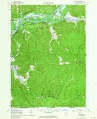
1962 Map of Red House
USGS Topo · Published 1964About this map
Alleghany State Park dominates this landscape, covering a vast expanse of forested ridges and deep hollows in Cattaraugus County. The 1962 survey captures the area during the development of the Allegheny Reservoir, with blue-shaded zones along the Allegheny River indicating land subject to controlled inundation. This transformation impacted several local landmarks and transit routes, including sections of the Erie-Lackawanna railroad and the riverfront community of Red House.
Find a feature on this map
53 named features on this map. Tap any name to fly to it.
Don’t see what you’re looking for? This feature index may not catch every label — zoom into the map to look around manually.
Map Details
Editions of this 1962 Red House Map
4 editions found
Other maps of this area

1900 · Salamanca
USGS Topo · 1:62,500

1922 · Randolph
USGS Topo · 1:62,500

1923 · Randolph
USGS Topo · 1:62,500

1924 · Bradford
USGS Topo · 1:62,500

1926 · Bradford
USGS Topo · 1:62,500

1936 · Kinzua
USGS Topo · 1:48,000

1938 · Salamanca
USGS Topo · 1:62,500

1941 · Kinzua
USGS Topo · 1:62,500

1941 · Bradford
USGS Topo · 1:62,500

1943 · Randolph
USGS Topo · 1:62,500