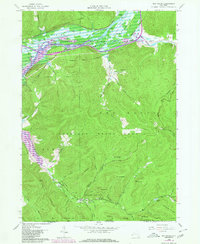
1962 Map of Red House
USGS Topo · Published 1980About this map
Allegany State Park dominates this terrain, where the peaks of Mt Seneca, Mt Onondaga, and Mt Oneida rise above a complex network of hollows and brooks. To the north, the Allegheny River and its accompanying Allegheny River Reservoir define the valley floor, carving through the Allegheny Indian Reservation. The map captures a landscape shaped by both recreation and transit, with Quaker Lake and Science Lake serving as interior landmarks alongside Camp Turner and Camp No 5. Transportation history is visible in the corridor following the river, where the Conrail line runs parallel to an Old Railroad Grade. This intersection of industrial rail heritage and protected woodland is punctuated by local centers of community like Red House, which features St Johns Ch and a Cem, alongside the Red House Chapel further east.
Find a feature on this map
61 named features on this map. Tap any name to fly to it.
Don’t see what you’re looking for? This feature index may not catch every label — zoom into the map to look around manually.
Map Details
Editions of this 1962 Red House Map
4 editions found
Other maps of this area

1900 · Salamanca
USGS Topo · 1:62,500

1922 · Randolph
USGS Topo · 1:62,500

1923 · Randolph
USGS Topo · 1:62,500

1924 · Bradford
USGS Topo · 1:62,500

1926 · Bradford
USGS Topo · 1:62,500

1936 · Kinzua
USGS Topo · 1:48,000

1938 · Salamanca
USGS Topo · 1:62,500

1941 · Kinzua
USGS Topo · 1:62,500

1941 · Bradford
USGS Topo · 1:62,500

1943 · Randolph
USGS Topo · 1:62,500