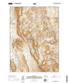
2020 Map of Red Lookout Butte
USGS Topo · Published 2020About this map
Buckskin Mtn Lookout Butte and Red Lookout Butte anchor this high-elevation landscape in Harney County, where the terrain is defined by volcanic features and critical water catchments. The northern portion of the quadrangle is dominated by the steep escarpments of the Tule Springs Rims, while the southern reaches show a network of managed water sources including Buckskin Reservoir Number 3 and Buckskin Reservoir Number 2. These reservoirs, along with Buckskin Spring, represent the vital infrastructure needed to sustain livestock and wildlife in the arid high desert. The mapping of township and range lines, such as t37s r35e and t38s r37e, illustrates the systematic grid overlaying this remote corner of Oregon.
Find a feature on this map
12 named features on this map. Tap any name to fly to it.
Don’t see what you’re looking for? This feature index may not catch every label — zoom into the map to look around manually.
Map Details
Editions of this 2020 Red Lookout Butte Map
This is the sole edition of this map. No revisions or reprints were ever made.
Other maps of this area

1955 · Adel
USGS Topo · 1:250,000

1957 · Adel
USGS Topo · 1:250,000

1958 · Adel
USGS Topo · 1:250,000

1962 · Adel
USGS Topo · 1:250,000

1971 · Andrews
USGS Topo · 1:24,000

1971 · Borax Lake
USGS Topo · 1:24,000

1981 · Tule Springs
USGS Topo · 1:24,000

1981 · Tule Springs NE
USGS Topo · 1:24,000
1981 · Tumtum Lake
USGS Topo · 1:24,000
1981 · Red Mountain
USGS Topo · 1:24,000