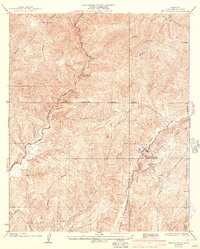
1936 Map of Red Mountain
USGS Topo · Published 1943About this map
San Francisquito Power House No 2 stands as a focal point of infrastructure in this 1941 revised landscape, highlighting the critical role of water and power management in the San Francisquito region. The industrial character of the era is clearly visible through the winding path of the Los Angeles Aqueduct and the Los Angeles Transmission Line, which carve through the high terrain. These engineering feats are contrasted by remote outposts such as the Elizabeth Lake Guard Station and the Warm Spring Lookout, reflecting the ongoing efforts in fire prevention and forest management. Local life is anchored by the Bee Sch and a Public Camp, while the natural drainage system of Elizabeth Lake Canyon and San Francisquito Canyon defines the steep topography. The presence of Drinkwater Reservoir further emphasizes the mid-century focus on securing resources for the growing coastal population.
Find a feature on this map
23 named features on this map. Tap any name to fly to it.
Don’t see what you’re looking for? This feature index may not catch every label — zoom into the map to look around manually.
Map Details
Editions of this 1936 Red Mountain Map
4 editions found
Other maps of this area

1900 · Fernando
USGS Topo · 1:62,500

1901 · Southern California Sheet No. 1
USGS Topo · 1:250,000

1903 · Tejon
USGS Topo · 1:125,000

1903 · Camulos
USGS Topo · 1:125,000

1903 · Santa Susana
USGS Topo · 1:62,500

1904 · Southern California Sheet No. 1
USGS Topo · 1:250,000

1915 · Elizabeth Lake
USGS Topo · 1:125,000

1917 · Elizabeth Lake
USGS Topo · 1:125,000

1929 · Saugus
USGS Topo · 1:24,000

1931 · Red Mountain
USGS Topo · 1:24,000