
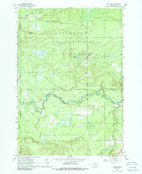
1963 Map of Red Oak
USGS Topo · Published 1964About this map
The Au Sable River winds through this northern Michigan landscape, defining the transition between the Greenwood State Forest and the Huron National Forest. In the early 1960s, the small settlement of Red Oak sat just south of Glenn Lake, serving as a central point in a territory largely defined by timber and conservation. The terrain is crisscrossed by numerous waterways, including Beaver Creek and Sohn Creek, which feed into the larger river system.
Find a feature on this map
18 named features on this map. Tap any name to fly to it.
Don’t see what you’re looking for? This feature index may not catch every label — zoom into the map to look around manually.
Map Details
Editions of this 1963 Red Oak Map
2 editions found
Other maps of this area

1949 · Lewiston
USGS Topo · 1:62,500

1950 · Comstock Hills
USGS Topo · 1:24,000

1950 · Lovells
USGS Topo · 1:24,000

1951 · Comstock Hills
USGS Topo · 1:24,000

1951 · Lovells
USGS Topo · 1:24,000

1954 · Traverse City
USGS Topo · 1:250,000

1955 · Comins
USGS Topo · 1:62,500

1958 · Traverse City
USGS Topo · 1:250,000

1963 · Luzerne
USGS Topo · 1:24,000

1963 · Eldorado
USGS Topo · 1:24,000
Featured Places
- Big Creek Township, MI
- Lovells Township, MI
- South Branch Township, MI
- Red Oak, Greenwood Township
- Elmer Township, MI