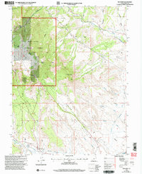
2001 Map of Red Point
USGS Topo · Published 2004About this map
Industrial extraction and high-desert water management define this portion of the Manti-La Sal National Forest at the turn of the 21st century. The map documents a landscape of significant coal mining history, marked by the Des-Bee-Dove Mines, Deer Creek Mine, and the Wilberg Mine Historical Monument. A distinctive conveyor system and numerous 4wd tracks illustrate the infrastructure required to move resources through the steep canyons and gulches of the Wasatch Plateau.
Find a feature on this map
40 named features on this map. Tap any name to fly to it.
Don’t see what you’re looking for? This feature index may not catch every label — zoom into the map to look around manually.
Map Details
Editions of this 2001 Red Point Map
This is the sole edition of this map. No revisions or reprints were ever made.
Other maps of this area

1885 · Manti
USGS Topo · 1:250,000

1886 · Price River
USGS Topo · 1:250,000

1895 · Manti
USGS Topo · 1:250,000

1896 · Price River
USGS Topo · 1:250,000

1923 · Castle Dale
USGS Topo · 1:62,500

1923 · Hiawatha
USGS Topo · 1:62,500

1925 · Castle Dale
USGS Topo · 1:62,500

1925 · Hiawatha
USGS Topo · 1:62,500

1956 · Price
USGS Topo · 1:250,000

1960 · Price
USGS Topo · 1:250,000