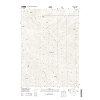
2013 Map of Red Ridge
USGS Topo · Published 2013About this map
Caribou National Forest dominates this section of Bonneville County, where high ridges and deep drainages define the remote terrain. The presence of Camp Ta-Man-a-Wis in the northern reaches suggests seasonal human activity within an otherwise largely undeveloped wilderness. Notable landmarks such as Red Peak and Congress Knob provide high-ground orientation points above the complex network of watercourses, including Bear Cr and N-Fork Bear Cr. This 2013 survey reveals a landscape shaped by natural erosion and drainage patterns, from the steep Little Box Canyon to the broad expanse of Fourth of July Ridge. The intricate naming of smaller features like Deadhorse Ridge and Golden Gate reflects a geography deeply mapped for forest management and navigation by those traversing these interior Idaho highlands.
Find a feature on this map
37 named features on this map. Tap any name to fly to it.
Don’t see what you’re looking for? This feature index may not catch every label — zoom into the map to look around manually.
Map Details
Editions of this 2013 Red Ridge Map
This is the sole edition of this map. No revisions or reprints were ever made.
Other maps of this area

1932 · Irwin
USGS Topo · 1:96,000

1935 · Irwin
USGS Topo · 1:125,000

1955 · Driggs
USGS Topo · 1:250,000

1958 · Driggs
USGS Topo · 1:250,000

1962 · Driggs
USGS Topo · 1:250,000

1966 · Big Elk Mtn
USGS Topo · 1:24,000

1966 · Conant Valley
USGS Topo · 1:24,000
1966 · Thompson Peak
USGS Topo · 1:24,000
1966 · Herman
USGS Topo · 1:24,000
1966 · Commissary Ridge
USGS Topo · 1:24,000