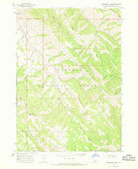
1966 Map of Commissary Ridge
USGS Topo · Published 1969About this map
Caribou National Forest defines this high-altitude landscape in eastern Idaho, characterized by a complex system of prominent geographic spines including Commissary Ridge and the distinctively named Fourth of July Ridge. The 1966 field survey documents a remote wilderness environment where movement is dictated by a network of specialized routes, from the Skyline Road traversing southern heights to numerous pack trails and jeep trails that thread through deep drainages. Headwaters for local drainages like Fall Creek and North Fork Bear Creek emerge from the steep slopes of Lightning Ridge and Deadhorse Ridge. This map captures the area as it was managed in the mid-1960s, showing the intersection of forest boundaries and topographic landmarks like Flag Knoll and Three Knolls, serving as an essential reference for understanding the backcountry infrastructure of Bonneville County.
Find a feature on this map
34 named features on this map. Tap any name to fly to it.
Don’t see what you’re looking for? This feature index may not catch every label — zoom into the map to look around manually.
Map Details
Editions of this 1966 Commissary Ridge Map
2 editions found
Other maps of this area

1917 · Cranes Flat
USGS Topo · 1:62,500

1924 · Hell Creek
USGS Topo · 1:62,500

1926 · Hell Creek
USGS Topo · 1:62,500

1932 · Irwin
USGS Topo · 1:96,000

1935 · Irwin
USGS Topo · 1:125,000

1955 · Driggs
USGS Topo · 1:250,000

1958 · Driggs
USGS Topo · 1:250,000

1962 · Driggs
USGS Topo · 1:250,000

1966 · Big Elk Mtn
USGS Topo · 1:24,000

1966 · Conant Valley
USGS Topo · 1:24,000