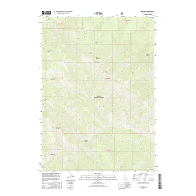
2017 Map of Red Ridge
USGS Topo · Published 2017About this map
Caribou National Forest dominates this high-altitude landscape in Bonneville County, where deep canyons and prominent ridges define the watershed of the Snake River basin. The terrain rises to several distinct summits, including Red Peak and Congress Knob, while the northern portion is carved by Little Box Canyon and Box Canyon. A complex network of drainages such as Indian Cr, Bear Cr, and Deadman Cr weave through the forest, suggesting the seasonal water patterns of this montane environment. The map details a landscape largely shaped by its topography, where named features like Golden Gate and Deadhorse Ridge provide essential landmarks for navigation through the wilderness. These labels reflect a history of local geographic naming tied to early exploration and land use, from the commemorative Fourth of July Ridge to the descriptive Dry Hollow.
Find a feature on this map
36 named features on this map. Tap any name to fly to it.
Don’t see what you’re looking for? This feature index may not catch every label — zoom into the map to look around manually.
Map Details
Editions of this 2017 Red Ridge Map
This is the sole edition of this map. No revisions or reprints were ever made.
Other maps of this area

1932 · Irwin
USGS Topo · 1:96,000

1935 · Irwin
USGS Topo · 1:125,000

1955 · Driggs
USGS Topo · 1:250,000

1958 · Driggs
USGS Topo · 1:250,000

1962 · Driggs
USGS Topo · 1:250,000

1966 · Big Elk Mtn
USGS Topo · 1:24,000

1966 · Conant Valley
USGS Topo · 1:24,000
1966 · Thompson Peak
USGS Topo · 1:24,000
1966 · Herman
USGS Topo · 1:24,000
1966 · Commissary Ridge
USGS Topo · 1:24,000