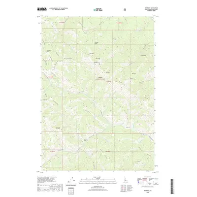
2020 Map of Red Ridge
USGS Topo · Published 2020About this map
Caribou National Forest dominates this landscape in Bonneville County, where the high ridges of eastern Idaho form a complex network of canyons and gulches. The terrain is defined by dramatic elevation changes at Red Peak and Elk Mountain, with the watershed feeding numerous tributaries like Deadman Cr and Yeaman Creek. This 2020 survey illustrates a wilderness primarily utilized for resource management and backcountry navigation, as evidenced by the system of fire roads and the Bear Creek/Sheep trail.
Find a feature on this map
51 named features on this map. Tap any name to fly to it.
Don’t see what you’re looking for? This feature index may not catch every label — zoom into the map to look around manually.
Map Details
Editions of this 2020 Red Ridge Map
This is the sole edition of this map. No revisions or reprints were ever made.
Other maps of this area

1932 · Irwin
USGS Topo · 1:96,000

1935 · Irwin
USGS Topo · 1:125,000

1955 · Driggs
USGS Topo · 1:250,000

1958 · Driggs
USGS Topo · 1:250,000

1962 · Driggs
USGS Topo · 1:250,000

1966 · Big Elk Mtn
USGS Topo · 1:24,000

1966 · Conant Valley
USGS Topo · 1:24,000
1966 · Thompson Peak
USGS Topo · 1:24,000
1966 · Herman
USGS Topo · 1:24,000
1966 · Commissary Ridge
USGS Topo · 1:24,000