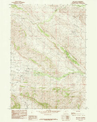
1985 Map of Red Ridge
USGS Topo · Published 1985About this map
Grass Creek Basin defines the central landscape of this mid-1980s Hot Springs County survey, where the drainages of Grass Creek and its various tributaries cut through a series of prominent topographic uplifts. The map provides a clear picture of the region's geologic and extractive potential, notably marked by Coalmine Gulch and an identified Prospect, indicating the historical significance of coal and mineral interest in this part of Wyoming.
Find a feature on this map
13 named features on this map. Tap any name to fly to it.
Don’t see what you’re looking for? This feature index may not catch every label — zoom into the map to look around manually.
Map Details
Editions of this 1985 Red Ridge Map
This is the sole edition of this map. No revisions or reprints were ever made.
Other maps of this area

1913 · Grass Creek Basin
USGS Topo · 1:62,500

1914 · Blue Mesa
USGS Topo · 1:62,500

1915 · Grass Creek Basin
USGS Topo · 1:62,500

1916 · Blue Mesa
USGS Topo · 1:62,500

1951 · Hillberry Rim
USGS Topo · 1:24,000

1951 · Dutch Nick Flat SW
USGS Topo · 1:24,000

1951 · Gillies Draw
USGS Topo · 1:24,000

1955 · Cody
USGS Topo · 1:250,000

1955 · Thermopolis
USGS Topo · 1:250,000

1958 · Cody
USGS Topo · 1:250,000