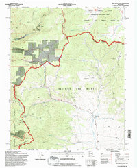
1995 Map of Red River Pass
USGS Topo · Published 1997About this map
Beaubien and Miranda Grant (Maxwell) lands dominate this high-altitude landscape along the border of Taos and Colfax counties. The map records a complex overlay of historic land grants and modern federal management, featuring the Sangre de Cristo Grant to the north and the Wheeler Peak Wilderness to the south. Transportation and recreation follow the rugged terrain, with Red River Pass and Bobcat Pass serving as vital crossings, while the Enchanted Forest Cross Country Ski Area marks the area's development for outdoor leisure.
Find a feature on this map
45 named features on this map. Tap any name to fly to it.
Don’t see what you’re looking for? This feature index may not catch every label — zoom into the map to look around manually.
Map Details
Editions of this 1995 Red River Pass Map
This is the sole edition of this map. No revisions or reprints were ever made.
Other maps of this area

1954 · Raton
USGS Topo · 1:250,000

1955 · Ute Park
USGS Topo · 1:62,500

1958 · Raton
USGS Topo · 1:250,000

1962 · Ash Mountain
USGS Topo · 1:62,500

1963 · Wheeler Peak
USGS Topo · 1:24,000

1963 · Eagle Nest
USGS Topo · 1:24,000

1963 · Red River Pass
USGS Topo · 1:24,000

1963 · Latir Peak
USGS Topo · 1:24,000

1963 · Comanche Point
USGS Topo · 1:24,000

1963 · Red River
USGS Topo · 1:24,000