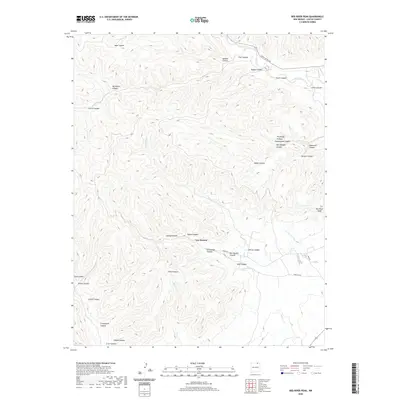
2020 Map of Red River Peak
USGS Topo · Published 2020About this map
Van Houten sits at the convergence of several drainages, serving as a rare point of human settlement in this high-altitude landscape. The surrounding terrain is defined by a dense network of canyons, including Graveyard Canyon, Van Houten Canyon, and Negro Canyon, which slice through the plateau. These features suggest a history of resource extraction and local navigation through the steep draws. The northeastern corner of the map is shaped by the Canadian River, which flows near names like Coal Canyon and Happy Canyon, indicating the industrial and topographic character of this Colfax County region. To the southeast, the elevation rises toward Red River Peak, overlooking the headwaters of Willow Cr and the distant Parker Arroyo.
Find a feature on this map
41 named features on this map. Tap any name to fly to it.
Don’t see what you’re looking for? This feature index may not catch every label — zoom into the map to look around manually.
Map Details
Editions of this 2020 Red River Peak Map
This is the sole edition of this map. No revisions or reprints were ever made.
Other maps of this area

1912 · Raton
USGS Topo · 1:62,500

1914 · Raton
USGS Topo · 1:62,500

1915 · Brilliant
USGS Topo · 1:62,500

1915 · Koehler
USGS Topo · 1:62,500

1917 · Koehler
USGS Topo · 1:62,500

1954 · Raton
USGS Topo · 1:250,000

1958 · Raton
USGS Topo · 1:250,000

1971 · Clifton House
USGS Topo · 1:24,000

1971 · Saltpeter Mountain
USGS Topo · 1:24,000
1971 · Raton
USGS Topo · 1:24,000