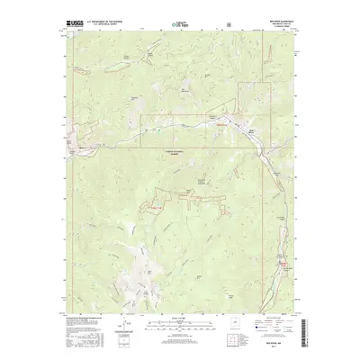
2017 Map of Red River
USGS Topo · Published 2017About this map
The Red River corridor and its high-elevation tributaries dominate this landscape within the Carson National Forest. The settlement of Red River sits at the confluence of several key drainages, including Bitter Cr and Mallette Cr, where the valley floor provides a narrow respite from the surrounding Taos Mountains. Evidence of the region's mining and recreational history is scattered throughout the drainages, from the community of Moly near Sulphur Gulch to the steep grades of the Red River Nature Trail. High alpine features like Gold Hill and Relica Peak define the southern skyline, overlooking a series of glacial basins containing Goose Lake and Pioneer Lake. The map details a complex network of forest access routes, including the Pioneer Creek and Lobo Peak trails, which navigate the dramatic vertical relief between the canyon bottoms and the high ridges of the Sangre de Cristo Mountains.
Find a feature on this map
56 named features on this map. Tap any name to fly to it.
Don’t see what you’re looking for? This feature index may not catch every label — zoom into the map to look around manually.
Map Details
Editions of this 2017 Red River Map
This is the sole edition of this map. No revisions or reprints were ever made.
Other maps of this area

1954 · Raton
USGS Topo · 1:250,000

1958 · Raton
USGS Topo · 1:250,000

1963 · Wheeler Peak
USGS Topo · 1:24,000

1963 · Eagle Nest
USGS Topo · 1:24,000

1963 · Arroyo Seco
USGS Topo · 1:24,000

1963 · Red River Pass
USGS Topo · 1:24,000

1963 · Cerro
USGS Topo · 1:24,000

1963 · Questa
USGS Topo · 1:24,000

1963 · Latir Peak
USGS Topo · 1:24,000

1963 · Comanche Point
USGS Topo · 1:24,000