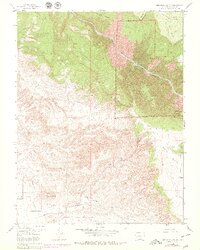
1955 Map of Red Rock Canyon
USGS Topo · Published 1979About this map
The Black Canyon of the Gunnison National Monument dominates the northeastern landscape of this mid-century study, showcasing the dramatic drop into the canyon floor where the Gunnison River carves through the terrain. The map captures the intricate water management systems essential to the region's development, including the Loutsenhizer canal and various ditch networks. Significant infrastructure is marked by the State Tunnel Dam and the State Tunnel (Alkali) near Bostwick. To the southwest, the topography levels out into North Mesa, where the land is scored by a complex system of canals and flumes. Notable peaks and landmarks such as Flat Top, Table Mount, and Green Mountain provide reference points for the transition from the high canyon rim down to the agricultural flats.
Find a feature on this map
21 named features on this map. Tap any name to fly to it.
Don’t see what you’re looking for? This feature index may not catch every label — zoom into the map to look around manually.
Map Details
Editions of this 1955 Red Rock Canyon Map
5 editions found
Other maps of this area

1909 · Montrose
USGS Topo · 1:125,000

1911 · Montrose
USGS Topo · 1:125,000

1955 · Olathe NW
USGS Topo · 1:24,000

1955 · Black Ridge
USGS Topo · 1:24,000

1955 · Olathe
USGS Topo · 1:24,000

1955 · Red Rock Canyon
USGS Topo · 1:24,000

1956 · Montrose
USGS Topo · 1:250,000

1957 · Cerro Summit
USGS Topo · 1:24,000

1957 · Grizzly Ridge
USGS Topo · 1:24,000

1959 · Montrose
USGS Topo · 1:250,000