
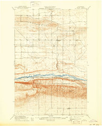
1911 Map of Red Rock
USGS Topo · Published 1911About this map
Saddle Mountains and the French Hills dominate this 1909 survey, framing a landscape defined by the arrival of the Chicago Milwaukee and Puget Sound railroad. This rail corridor follows the course of Crab Creek, establishing a line of small stations and settlements including Smyrna, Red Rock, and Colletta. The presence of several rural schoolhouses, such as Sumner School, Red Rock School, and McLeod School, indicates the early 20th-century effort to establish community infrastructure across the Coulee country. Beyond the tracks, the terrain reveals distinctive features like Cashs Butte and the Natural Corral, while Joyces Ranch marks the presence of early agricultural life on the plateau. The map captures a moment when new industrial transportation was first being integrated into a landscape of isolated ranches and difficult terrain.
Find a feature on this map
16 named features on this map. Tap any name to fly to it.
Don’t see what you’re looking for? This feature index may not catch every label — zoom into the map to look around manually.
Map Details
Editions of this 1911 Red Rock Map
2 editions found
Other maps of this area

1909 · Quincy
USGS Topo · 1:62,500

1910 · Quincy
USGS Topo · 1:62,500

1910 · Winchester
USGS Topo · 1:62,500

1912 · Moses Lake
USGS Topo · 1:62,500

1912 · Beverly
USGS Topo · 1:62,500

1916 · Coyote Rapids
USGS Topo · 1:62,500

1917 · Priest Rapids
USGS Topo · 1:62,500

1923 · Corfu
USGS Topo · 1:62,500

1924 · Hanford
USGS Topo · 1:62,500

1950 · Smyrna
USGS Topo · 1:62,500