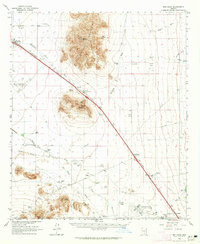
1963 Map of Red Rock
USGS Topo · Published 1965About this map
Newman Peak and the surrounding Picacho Mountains dominate the landscape of the Pinal County desert, where mid-century Arizona agriculture and infrastructure parallel the Southern Pacific tracks. Irrigation is central to the area's development, evidenced by the Greene Canal and Santa Cruz River feeding various mid-century operations like the Thompson Dairy, Aguirre Ranch, and Eloy Farms. Near the Picacho Pass, a Mormon Trail Historical Marker notes the area's significance for westward travelers.
Find a feature on this map
38 named features on this map. Tap any name to fly to it.
Don’t see what you’re looking for? This feature index may not catch every label — zoom into the map to look around manually.
Map Details
Editions of this 1963 Red Rock Map
3 editions found
Other maps of this area

1922 · Red Rock No 2
USGS Topo · 1:48,000

1922 · Signal Peak
USGS Topo · 1:62,500

1924 · Signal Peak
USGS Topo · 1:62,500

1934 · Tucson Mountains
USGS Topo · 1:125,000

1934 · Silver Bell
USGS Topo · 1:125,000

1934 · Newman Peak
USGS Topo · 1:125,000

1947 · Cortaro
USGS Topo · 1:62,500

1947 · Red Rock
USGS Topo · 1:62,500

1947 · Eloy
USGS Topo · 1:62,500

1948 · Eloy
USGS Topo · 1:62,500