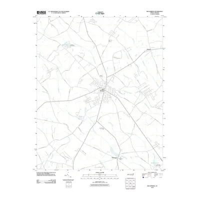
2010 Map of Red Springs
USGS Topo · Published 2010About this map
Red Springs serves as the central hub of this North Carolina landscape, where a dense network of roads like Watson Farm Rd and Highland Games Rd converge. The surrounding terrain is defined by a complex hydrologic system of named swamplands and branches, including the expansive Little Raft Swamp and Richland Swamp, which dictate the placement of local infrastructure and agricultural boundaries. To the south, the settlement of Philadelphus sits near the Richland Swamp and Big Buie Pond, reflecting a pattern of rural community development along these watercourses.
Find a feature on this map
68 named features on this map. Tap any name to fly to it.
Don’t see what you’re looking for? This feature index may not catch every label — zoom into the map to look around manually.
Map Details
Editions of this 2010 Red Springs Map
This is the sole edition of this map. No revisions or reprints were ever made.
Other maps of this area

1949 · Wagram
USGS Topo · 1:24,000

1949 · Wakulla
USGS Topo · 1:24,000

1949 · Laurinburg
USGS Topo · 1:62,500

1953 · Florence
USGS Topo · 1:250,000

1954 · Florence
USGS Topo · 1:250,000

1972 · Northwest Lumberton
USGS Topo · 1:24,000

1972 · Rennert
USGS Topo · 1:24,000
1972 · Raeford
USGS Topo · 1:24,000

1972 · Pembroke
USGS Topo · 1:24,000
1972 · Parkton
USGS Topo · 1:24,000