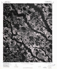
1976 Map of Red Springs
USGS Topo · Published 1978About this map
Red Springs occupies the central position on this Robeson County orthophotoquad, showing the town's structural layout in the mid-1970s. This aerial perspective, produced by the U.S. Geological Survey in cooperation with the Soil Conservation Service, reveals a landscape where organized town grids meet an intricate mosaic of dark, wooded drainages and light-toned agricultural fields. To the northeast, the settlement of Shannon appears as a smaller cluster along the rail and road corridor, while Philadelphus marks the southern reach of the sheet. The imagery provides a clear record of land use patterns, depicting the dense forest patches that border the area's characteristic Carolina bays and slow-moving watercourses, contrasting sharply with the cleared farmlands that define the regional economy.
Find a feature on this map
3 named features on this map. Tap any name to fly to it.
Don’t see what you’re looking for? This feature index may not catch every label — zoom into the map to look around manually.
Map Details
Editions of this 1976 Red Springs Map
This is the sole edition of this map. No revisions or reprints were ever made.
Other maps of this area

1949 · Wagram
USGS Topo · 1:24,000

1949 · Wakulla
USGS Topo · 1:24,000

1949 · Laurinburg
USGS Topo · 1:62,500

1953 · Florence
USGS Topo · 1:250,000

1954 · Florence
USGS Topo · 1:250,000

1972 · Northwest Lumberton
USGS Topo · 1:24,000

1972 · Rennert
USGS Topo · 1:24,000
1972 · Raeford
USGS Topo · 1:24,000

1972 · Pembroke
USGS Topo · 1:24,000
1972 · Parkton
USGS Topo · 1:24,000