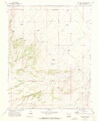
1970 Map of Red Top Ranch
USGS Topo · Published 1973About this map
Red Top Ranch and Freds Camp anchor this cattle country landscape, where the management of scarce water resources is the primary human imprint on the land. A complex system of named catchments like Studebaker Reservoir, Kierce Reservoir, and School Section Reservoir are distributed across the drainage basins of Chicosa Creek and Peterson Creek.
Find a feature on this map
37 named features on this map. Tap any name to fly to it.
Don’t see what you’re looking for? This feature index may not catch every label — zoom into the map to look around manually.
Map Details
Editions of this 1970 Red Top Ranch Map
2 editions found
Other maps of this area

1891 · Nepesta
USGS Topo · 1:125,000

1891 · Apishapa
USGS Topo · 1:125,000

1893 · Nepesta
USGS Topo · 1:125,000

1893 · Apishapa
USGS Topo · 1:125,000

1897 · Apishapa
USGS Topo · 1:125,000

1904 · Nepesta
USGS Topo · 1:125,000

1954 · Trinidad
USGS Topo · 1:250,000

1954 · Pueblo
USGS Topo · 1:250,000

1955 · Trinidad
USGS Topo · 1:250,000

1957 · Pueblo
USGS Topo · 1:250,000