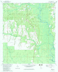
1982 Map of Redbay
USGS Topo · Published 1983About this map
The Choctawhatchee River defines the eastern edge of this landscape, its winding course and numerous cutoff lakes like Horseshoe Lake and Endless Lake shaping the wet lowlands of Buzzard Roost Swamp. On the higher ground to the west, the settlement of Redbay serves as a central point among family-named landmarks including McKinnon Hill, Hunter Hill, and Crawford Hill. The area's early industrial and social history is etched into the terrain through features like Sugar Mill Branch and Mill Branch, alongside community hubs such as Mt Olive Ch and the Antioch Cem near Battle Ground Forks. This 1980s revision of earlier surveys preserves the location of traditional river access points like Story Landing and the Lookout Tower overlooking the complex drainage network of Seven Runs and McCallum Branch.
Find a feature on this map
69 named features on this map. Tap any name to fly to it.
Don’t see what you’re looking for? This feature index may not catch every label — zoom into the map to look around manually.
Map Details
Editions of this 1982 Redbay Map
This is the sole edition of this map. No revisions or reprints were ever made.
Other maps of this area

1935 · De Funiak Springs
USGS Topo · 1:48,000

1936 · Point Washington
USGS Topo · 1:48,000

1938 · De Funiak Springs
USGS Topo · 1:62,500

1939 · Point Washington
USGS Topo · 1:62,500

1944 · Bruce
USGS Topo · 1:24,000

1945 · Red Head
USGS Topo · 1:31,680

1945 · Bruce
USGS Topo · 1:31,680

1948 · Ponce De Leon
USGS Topo · 1:24,000

1949 · Millers Ferry
USGS Topo · 1:24,000

1949 · Redbay
USGS Topo · 1:24,000