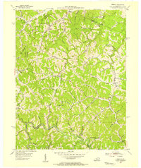
1954 Map of Redbush
USGS Topo · Published 1955About this map
Redbush and Flatgap center this mid-century view of the Kentucky foothills, where the boundaries of Lawrence, Johnson, and Morgan Counties converge. The landscape is defined by the extensive Gas and Oil Field activities that dot the ridges and creek valleys, showing the industrial footprint of the early 1950s. Rural life is anchored by several local institutions, including Old Bethel Ch, Laurel Hill Sch, and Burchett Flat Sch, which served the dispersed populations living along the narrow bottomlands of Blaine Creek and Paint Creek. The map documents a dense network of mountain roads, including KY 172, linking small settlements like Terryville, Keaton, and Relief. For those tracing family history in this corner of the Cumberland Plateau, the topography illustrates how the steep ridges dictated the placement of homes, schools, and family cemeteries away from the larger valley floors.
Find a feature on this map
63 named features on this map. Tap any name to fly to it.
Don’t see what you’re looking for? This feature index may not catch every label — zoom into the map to look around manually.
Map Details
Editions of this 1954 Redbush Map
This is the sole edition of this map. No revisions or reprints were ever made.
Other maps of this area

1886 · Prestonsburg
USGS Topo · 1:125,000

1889 · Salyersville
USGS Topo · 1:125,000

1891 · Salyersville
USGS Topo · 1:125,000

1892 · Prestonsburg
USGS Topo · 1:125,000

1899 · Salyersville
USGS Topo · 1:125,000

1903 · Kenova
USGS Topo · 1:125,000

1904 · Kenova
USGS Topo · 1:125,000

1915 · Paintsville
USGS Topo · 1:48,000

1917 · Paintsville
USGS Topo · 1:62,500

1950 · Isonville
USGS Topo · 1:24,000