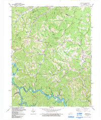
1992 Map of Redbush
USGS Topo · Published 1992About this map
Paintsville Lake State Wildlife Mgmt Area dominates the southern portion of this landscape, where the rising waters of the lake follow the winding course of Blaine Creek. The terrain is characterized by a dense network of branches and forks, such as Keaton Fork and Mudlick Creek, which support numerous small settlements and scattered homesteads. Industry is deeply integrated into the rural topography, with several extensive areas designated as Gas and Oil Fields or simply Gas Fields. These operations are interspersed among community landmarks like Keaton Fork Ch and Point Pleasant Ch, alongside dozens of unnamed family cemeteries. The presence of a Natural Bridge near Robinson Branch highlights the distinct geological character of this part of the Cumberland Plateau, where traditional hill-country life exists alongside modern resource extraction and state-managed conservation lands.
Find a feature on this map
67 named features on this map. Tap any name to fly to it.
Don’t see what you’re looking for? This feature index may not catch every label — zoom into the map to look around manually.
Map Details
Editions of this 1992 Redbush Map
This is the sole edition of this map. No revisions or reprints were ever made.
Other maps of this area

1886 · Prestonsburg
USGS Topo · 1:125,000

1889 · Salyersville
USGS Topo · 1:125,000

1891 · Salyersville
USGS Topo · 1:125,000

1892 · Prestonsburg
USGS Topo · 1:125,000

1899 · Salyersville
USGS Topo · 1:125,000

1903 · Kenova
USGS Topo · 1:125,000

1904 · Kenova
USGS Topo · 1:125,000

1915 · Paintsville
USGS Topo · 1:48,000

1917 · Paintsville
USGS Topo · 1:62,500

1950 · Isonville
USGS Topo · 1:24,000