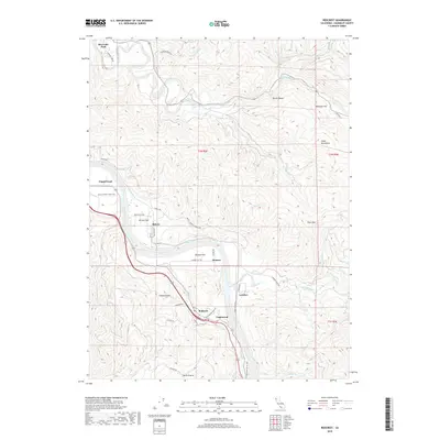
2018 Map of Redcrest
USGS Topo · Published 2018About this map
Redcrest sits at the heart of this Humboldt County corridor where the Eel River dictates the layout of human settlement. The landscape is a mix of alluvial flats and steep rises, with communities like Shively, Holmes, and Englewood positioned on level ground near the water. Movement through this timber-rich region is traced by the Pacific Lumber Company Rd and numerous local routes like Shively Rd and Peavine Rd. The river's influence is evident in the naming of large open areas such as Shively Flat and Holmes Flat. To the east, the terrain climbs toward the Chalk Mountains and Clark Mtn, while recreational access is highlighted by the Drury-Chaney Loop Trail and the High Rock River Trail winding along the valley floor. The map also captures several traditional prairies, including Chadd Prairie and Horse Prairie, which punctuate the dense forest cover of the Eel River basin.
Find a feature on this map
59 named features on this map. Tap any name to fly to it.
Don’t see what you’re looking for? This feature index may not catch every label — zoom into the map to look around manually.
Map Details
Editions of this 2018 Redcrest Map
This is the sole edition of this map. No revisions or reprints were ever made.
Other maps of this area

1919 · Glynn
USGS Topo · 1:62,500

1921 · Dyerville
USGS Topo · 1:62,500

1922 · Kneeland
USGS Topo · 1:62,500

1944 · Fortuna
USGS Topo · 1:62,500

1949 · Eureka
USGS Topo · 1:250,000

1949 · Weott
USGS Topo · 1:62,500

1950 · Iaqua Buttes
USGS Topo · 1:62,500

1950 · Scotia
USGS Topo · 1:62,500

1951 · Scotia
USGS Topo · 1:62,500

1951 · Weott
USGS Topo · 1:62,500