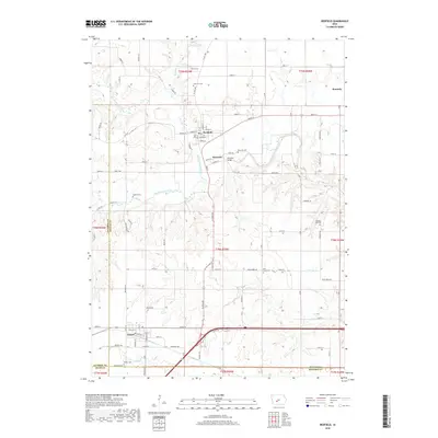
2018 Map of Redfield
USGS Topo · Published 2018About this map
Redfield and Wiscotta sit at the geographic heart of this landscape, situated along the meandering course of the Middle Raccoon River. This 2018 survey illustrates the rural character of the region where Dallas Co meets its neighbors, Guthrie and Madison counties. The map provides a detailed view of several cemeteries that speak to the long-standing community roots here, including Harper Cem, East Linn Cem, and Wiscotta Cem. Further south, the town of Dexter serves as a local hub near the southern edge of the sheet. The drainage patterns of Mosquito Cr, South Raccoon River, and Bear Cr define the land's contours, influencing the placement of historical road networks like Dextfield Rd and Creamery Rd. The proximity of small settlements like Kennedy further reveals the distribution of population centers throughout the townships of t79n r29w and t78n r29w.
Find a feature on this map
86 named features on this map. Tap any name to fly to it.
Don’t see what you’re looking for? This feature index may not catch every label — zoom into the map to look around manually.
Map Details
Editions of this 2018 Redfield Map
This is the sole edition of this map. No revisions or reprints were ever made.
Other maps of this area

1949 · Adel
USGS Topo · 1:62,500

1951 · Adel
USGS Topo · 1:62,500

1952 · Panora
USGS Topo · 1:62,500

1952 · Winterset
USGS Topo · 1:62,500

1954 · Greenfield
USGS Topo · 1:62,500

1954 · Omaha
USGS Topo · 1:250,000

1957 · Omaha
USGS Topo · 1:250,000

1958 · Omaha
USGS Topo · 1:250,000
1982 · Panther
USGS Topo · 1:24,000

1982 · Panora
USGS Topo · 1:24,000