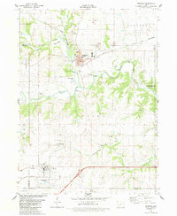
1982 Map of Redfield
USGS Topo · Published 1983About this map
The confluence of the Middle Raccoon River and the South Raccoon River anchors the geography of this central Iowa landscape in the early 1980s. The settlement of Redfield serves as a primary hub, characterized by its industrial activity near the riverbanks, including several claypits, kilns, and a Gravel Pit. To the south, the Iowa Railroad cuts through the town of Dexter, while the Chicago and North Western line tracks along the northern river valley. This survey reveals a high density of rural markers essential for genealogical research, such as the Bear Creek Ch and Pleasant Hill Cem. The land use is notably diverse, showing a balance between active extraction sites, community centers like the Redfield Community Sch, and conservation areas including the Pleasant Valley State Wildlife Area.
Find a feature on this map
50 named features on this map. Tap any name to fly to it.
Don’t see what you’re looking for? This feature index may not catch every label — zoom into the map to look around manually.
Map Details
Editions of this 1982 Redfield Map
This is the sole edition of this map. No revisions or reprints were ever made.
Other maps of this area

1949 · Adel
USGS Topo · 1:62,500

1951 · Adel
USGS Topo · 1:62,500

1952 · Panora
USGS Topo · 1:62,500

1952 · Winterset
USGS Topo · 1:62,500

1954 · Greenfield
USGS Topo · 1:62,500

1954 · Omaha
USGS Topo · 1:250,000

1957 · Omaha
USGS Topo · 1:250,000

1958 · Omaha
USGS Topo · 1:250,000
1982 · Panther
USGS Topo · 1:24,000

1982 · Panora
USGS Topo · 1:24,000